Facts
Culture
Travel
Beaches
Porto de Galinhas
Hotels
Restaurants
World Cup
Olinda
Pernambuco
|
Afogados da Ingazeira - Pernambuco
«Recife
«Cities of Pernambuco
Population: 34.618 inhabitants
Area: 378 km2
Distance from Recife: 379 km
Accesses: PE-292, PE-275, PE-280, BR-110, BR-232. Visit also maps of Recife and Pernambuco.
History
The city of Afogados da Ingazeira originated from a farm wich belonged to Manuel Francisco da Silva. Around the 1870s, the number of houses had grown big enough to justify the creation of a new city.
The name in Portuguese means Drowned of the Ingazeira.
Origin of the name: a long time ago, a couple tried to get cross the Pajeú river during high tide, was washed away and disappeared; a few days later their corpses were found.
 As that district was a part of the city of Ingazeira (a kind of tree typical of the region), the new city which formed became known as Afogados da Ingazeria (Drowned of Ingazeira).
The city of Ingazeira still exists, although, with less than 5.000 inhabitants, it is quite smaller than Afogados da Ingazeira.
The municipal district of Afogados da Ingazeria was separated from the city of Ingazeira by the Provincial Law of number 295, in May 05 of 1852. Later, in 1909, was promoted to the category of city.
The city of Afogados da Ingazeria comprehends also the districts of Vila da Carapuça and Queimada Grande.
Afogados da Ingazeira commemorates its political emancipation on July first.
Economy
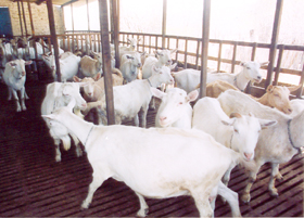 The main activity of the city is agribusiness, with rudimentary practices. Cattle is raised for production of milk, beef and leather; goat (picture) is an important activity, supplying goat beef to the region and to the crescent demand in the capital, Recife. The agriculture is mostly for subsistence, with cultures of the corn, manioc and fruits.
Another relevant activity is handcrafting: the city is known for producing stuffed fabric dolls, which are distributed all over the State. This activity, which requires little technology, generates a good number of jobs for the population of the city.
Afogados da Ingazeira is located in the region of Pajeú, in the Sertão Pernambucano (see map of Pernambuco).
With an area of 8.689 km², the region of Pajéu covers about 9% of the State territory and it is composed by 17 municipal districts: Afogados da Ingazeira, Brejinho, Calumbi, Carnaíba, Flores, Iguaraci, Ingazeira, Itapetim, Mirandiba, Quixaba, Santa Cruz da Baixa Verde, Santa Terezinha, São José do Belmonte, São José do Egito, Serra Talhada, Solidão, Tabira, Triunfo and Tuparetama.
Tourism
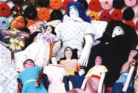 Afogados de Ingazeira offers natural beauties and a workmanship that surprises its visitors, with a special mention to the traditional fabric dolls (picture), of different shapes and sizes.
One of the principal touristic points of the city is the Serra do Giz, where many rupestrian drawings were found; the area is visited for study, research and contemplation.
In the month of July, after the celebrations of São João, the city is taken by stalls on the streets selling dolls and food. The city celebrates the emancipation with the Festival Regional da Sanfona (Regional Festival of Accordeosn), one of the greatest parties of Afogados and Pernambuco.
Source of information: IBGE and Government of the State of Pernambuco
Credit of photos: Government of the State of Pernambuco.
Other sites:
Afogados da Ingazeira. Photos and Stories about the city of Afogados da Ingazeira - in Portuguese only.
|
|