Facts
Culture
Travel
Beaches
Porto de Galinhas
Hotels
Restaurants
World Cup
Olinda
Pernambuco
|
Map of Pernambuco
«Recife
«Basic Info
«Maps
It stands to the eyes that Pernambuco is much larger across than down.
From east to west, the State is about 800 km wide (Petrolina, the largest city in the western extreme, is 716 km distant from Recife); from North to South, the State is about 200 km long (the beaches of Pernambuco are spread across 187 km of coast.)
The coast is the most densely populated area. The biggest city is the capital, Recife (pop. 1.486.869, estimative for year 2004 by IBGE); the next cities by population are Jaboatão dos Guararapes (pop. 630.008) and Olinda (pop. 381.502).
Besides these cities, the metropolitan area of Recife, as defined by law, comprehends also the cities of Paulista, Abreu e Lima, Igarassu, Camaragibe, Cabo de Santo Agostinho and São Lourenço da Mata; the metropolitan area has a population of about 4 million people.
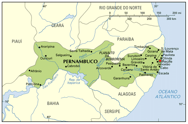
The State is physically divided into three regions:
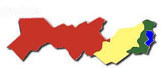 1) The coastal zone, called in Portuguese "Zona da Mata" (Mata is a reference to the forests which once existed there), a few tens of kilometers wide. The climate is tropical, with a wet season (usually from April through August). Soil is fertile, proper for the cultures of sugarcane, which have been cultivated since the 1500s. Most of population is concentrated here, as well as the industrial zones of the State. In this map, Zona da Mata is marked in green; the area in blue is the metropolitan area of Recife (same physical characteristics as the Zona da Mata).
2) The interior outback is called "Sertão" in Portuguese (red area of the map). Climate is semi-arid, where raining is scarce and irregular; predominant vegetation is called "caatinga", with predominance of bushes and rare ocurrences of trees with wry stem and branches; see some photos of caatinga. Drought is a serious issue; the vast majority of population is poor; main activity is agriculture of subsistence, but the main source of family income is social security and welfare assistance. The sertão occupies more than half of Pernambuco; the city of Arcoverde, about 250 km west of Recife, is considered the entrance to the sertão; the largest cities of the sertão are those represented in the map above.
3) A zone of transition, called "Agreste" in Portuguese (yellow area of the map); climate, vegetation and economy are a transition between the coast and the sertão. Caruaru is the most important city in the Agreste of Pernambuco; other important cities are Gravatá, Arcoverde and Garanhuns.
Pernambuco is cut from South to North by a chain of mountains, called Planalto da Borborema; this plateau physically separates the coast from the sertão and, grosso modo, defines the boundaries of the Agreste. Some cities are located on top of Borborema, like Garanhuns and Gravatá (altitudes around 800 m), and have a colder climate.
The most important river in the Brazilian northeast is the São Francisco, which separates Pernambuco from Bahia (and then turns south, running between Alagoas and Sergipe); the São Francisco supplies water for the areas in its vicinity, helping diminish the effects of drought; a polemic project is under discussion to deviate an amount of water towards the States of Paraíba, Rio Grande do Norte and Ceará.
Most rivers in the sertão are intermitents: they dry out completely during the dry seasons. Because of this, a common source of water found in the sertões of Brazil is the "açudes": artificial lakes to collect water; most açudes are in private farms; however, there are some açudes built by the governments (this is a good way to generate jobs to people with little education) which are very big.
|
|