Facts
Culture
Travel
Beaches
Porto de Galinhas
Hotels
Restaurants
World Cup
Olinda
Pernambuco
|
Araripina - Pernambuco
«Recife
«Cities of Pernambuco
Population: 70.898 inhabitants
Area: 1.847 km2
Distance from the capital: 684 km
Access: BR-316 and BR-232 (via Salgueiro and Caruaru). Visit maps of Recife and Pernambuco.
History
Before being promoted to the category of municipal district,
Araripina used to be district of Ouricuri and was called São Gonçalo; at the time, the city had as few as ten houses and a small chapel of Nossa Senhora da Conceição (saint of the city).
With the arrival of the first Vicar, the village experienced a quick growth, and the first public school was opened. In 1928, the village was turned into a municipality 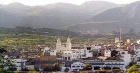 (gaining administrative and legislative autonomy) by the State law nr. 1.931 of September 11 of 1928. (gaining administrative and legislative autonomy) by the State law nr. 1.931 of September 11 of 1928.
The name Araripina is attributed, probably, to its proximity to the Chapada do Araripe, a mountain chain with several flat top hills.
Today, the city comprehends also the districts of Lagoa do Barro, Morais, Nascente, Rancharia and the village Gergelim.
Yearly, on September 11 Araripina celebrates its political emancipation.
Economy
Araripina has as principal economical activity the production of gypsum (picture),
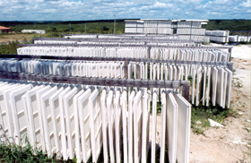 being one of the biggest gypsum's producer in Brazil; gypsum is widely employed in the civil construction in Brazil. being one of the biggest gypsum's producer in Brazil; gypsum is widely employed in the civil construction in Brazil.
Araripe concentrates 40% of the reserves of gipsita in the world.
This minerals reserves are one of the region's great distinctions, estimated in 1,2 billion of tons. The natural deposits of the mineral are spread across the districts of Araripina, Ipubi, Trindade, Bodocó and Ouricuri.
The Chapada do Araripe, with altitudes ranging between 850 e 1.000 meters, has an important role in the economy of the region. Besides the exploration of large reserves of gypsum, the mild climate on the top of the Chapada (in contrast with the hot and dry climate of Araripina) permits the cultivation of manioc and fruits, consumed in Araripina and several neighbour cities.
Another examples of economic activicy are the poultry's raising, the bees' farming and the goat's raising.
The Development Region of the Araripe, located in the Meso-region of the Pernambucan Backlands, represenst 18,8% of the State territory with 18.576,9 km² and comprehends also the municipal districts of Bodocó, Cedro, Exu, Granito, Ipubi, Moreilândia, Ouricuri, Parnamirim, Salgueiro, Santa Cruz, Santa Filomena, Serrita, Trindade and Verdejante.
Tourism
Araripina attracts visitors interested in the handcrafting focused on leather artifacts (picture).
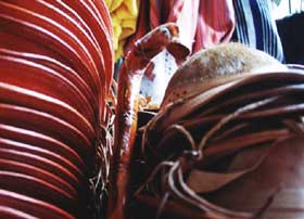 The production is mostly sold during the vaquejadas (kind of bull fights) that happens in the city (Araripina is included in a few vaquejada circuits). The production is mostly sold during the vaquejadas (kind of bull fights) that happens in the city (Araripina is included in a few vaquejada circuits).
One of the main attractions is the Museu Municipal (Municipal District Museum), which houses historic pieces of the city. The museum exhibits curious objects, such as photos, documetns, weapons and pieces of personal use which belonged to ancient residents.
About 20 km of the city, we find the Barragem de Lagoa do Barro (Dam of the Clay Lake). Besides fishing and boat riding, the spot is perfect to appreciate the scenery of the backlands; worth the while to wait for the sunset in the scrub-land scenery.
It may also be interesting to pay a visit to the Feira do Mercado Produtor (Market's Productor Fair), where small farmers sell their production directly to consumers.
Other sites:
Araripina.com.br Araripina's Portal.
Source of information: IBGE and Government of the State of Pernambuco
Credit of photos: Government of the State of Pernambuco.
|
|