|
|
Maps of Recife, Olinda and Pernambuco
«Recife
«Basic Info
Maps of Pernambuco
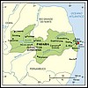 »Map of Pernambuco Description of the main physical characteristics of the State of Pernambuco.
»Transportation in Pernambuco Map with description of multimodal means of transportation (roads, airports, etc).
»Condition of federal roads in Pernambuco Map with up to date information about the federal highways.
»State highways Information about State roads in Pernambuco. Also, distances between cities and Pernambuco, and prices of bus tickets.
Maps of Recife
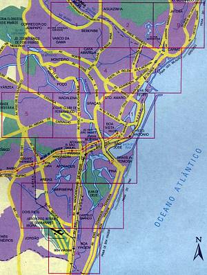 This map of Recife shows the city divided in 14 pieces.
For a better viewing and to follow the tips below, click the link to access an enlarged
map of Recife
A few hints about this map:
- the airport is in square #14, at the very bottom.
- the bus station is way off this map. To reach the station by car, you must take Av. Abdias de Carvalho (square #5) and drive about 10 km. The metro railways (the red line in squares #7 and #12) also go to the station.
- the Boa Viagem beach is in the shore line of squares #13 and #14; notice that the reefs along the beach are also drawn in the map.
- the Pina beach is in square #12.
- there are three main avenues which run all along Boa Viagem: Avenue Engenheiro Domingos Ferreira and Avenue Boa Viagem (both represented in the map) and Avenue Conselheiro Aguiar, which runs in between them (not represented in the map).
- to reach the Piedade beach, just follow Avenue Boa Viagem south.
- Olinda takes all of square #9 and the upper part of square #10. Reaching Olinda by car from Boa Viagem is straight forward: take Av. Boa Viagem, then Avenida Agamenon Magalhaes all the way up.
- to go to Gaibu, Muro Alto, Porto de Galinhas
and other beaches south of Recife, as well as the State of Alagoas, take BR-101 South (left side of square #8)
- to go to the beach of Itamaraca and the States of Paraiba and Rio Grande do Norte, take BR-101 North; from Boa Viagem, the easies way is to take Avenida Recife (squares #8 and #7) until it meets the BR-101. Notice, however, that some northern beaches (Paulista, Maria Farinha) are easierly reached by taking the Olinda route.
- most of Historic Recife is in square #11.
- the Rua do Bom Jesus is in the area around the letters RFFSA, in the map (RFFSA means Federal Rail Roads; it's still working, but transports only cargo, not passengers)
Other maps:
Central Recife - important touristic points Map showing the location of the most important touristic points in the central area of Recife
Recife Locator
Very helpful. You can search either by the part of the city (called bairro in Portuguese) you want to find or by a landmark reference (referencia). Just select what you want from the drop down menus and click the respective button.
More Maps
Maps of Olinda, Recife and the Pernambuco beaches
| |